Can We Predict Earthquakes? The Latest Technology and Research
By Sidra Tayyab · Education & Learning · 2025-09-02
Can We Predict Earthquakes? The Latest Technology and Research
Earthquakes remain one of the most destructive and least predictable natural disasters on Earth. Despite decades of research and enormous technological investment, scientists still cannot reliably predict exactly when and where a major earthquake will strike. But the science of earthquake forecasting has advanced dramatically, and new technologies are changing what's possible for early warning and risk assessment, even if precise prediction remains elusive.
Why Earthquake Prediction Is So Difficult
Earthquakes result from the sudden release of stress that has built up along fault lines over years or decades as tectonic plates grind against each other. The exact moment this stress overcomes friction and triggers a rupture depends on countless variables at the microscopic scale within rock formations kilometers underground — variables that are essentially impossible to measure directly with current technology. Unlike weather systems, which can be observed and modeled with satellites and sensors, the processes leading to an earthquake happen in opaque rock, hidden from direct observation.
The Difference Between Prediction and Forecasting
Scientists distinguish between earthquake "prediction" (specifying the exact time, location, and magnitude of a future earthquake) and "forecasting" (estimating the probability of an earthquake occurring in a region over a longer time period, such as years or decades). While precise prediction remains scientifically unachievable with current understanding, probabilistic forecasting has become increasingly sophisticated. The United States Geological Survey, for example, produces detailed probability maps estimating the likelihood of significant earthquakes in specific regions over 30-year periods, informing building codes and infrastructure planning.
Earthquake Early Warning Systems
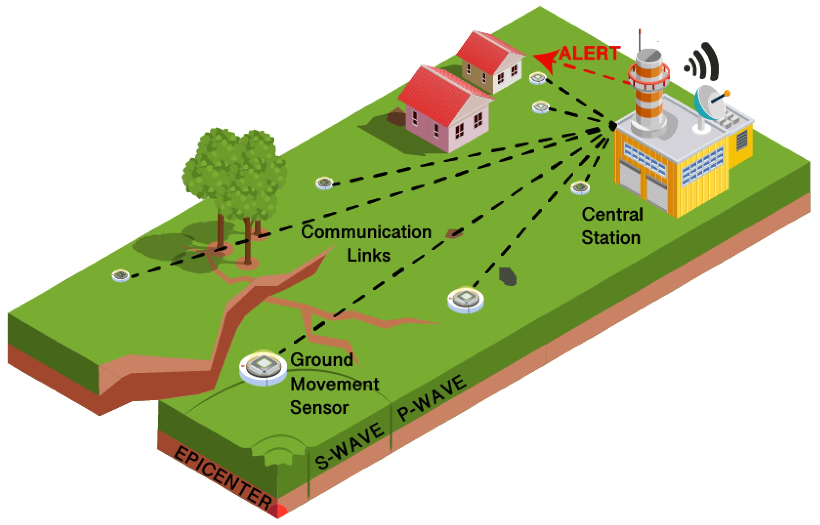
While predicting earthquakes before they begin remains impossible, detecting them in the crucial seconds after they begin has become remarkably effective. Earthquake early warning systems — like Japan's Earthquake Early Warning system, Mexico's SASMEX, and the West Coast United States' ShakeAlert — detect the fast-moving but less destructive P-waves that arrive before the slower, more damaging S-waves and surface waves. This provides seconds to tens of seconds of warning, enough time to stop trains, halt surgeries, open elevator doors, and alert people to take protective cover before the strongest shaking arrives.
Machine Learning and Big Data Approaches
Researchers are increasingly applying machine learning algorithms to enormous datasets of seismic activity, searching for subtle patterns that might precede major earthquakes. Some studies have identified statistical patterns in foreshock activity, minor ground deformation, and even changes in groundwater chemistry that correlate with subsequent major earthquakes in specific historical cases. However, these patterns have not yet proven reliable enough for operational prediction — many earthquakes occur without any detectable precursor signals, and many detected "precursor" patterns don't lead to major earthquakes, producing unacceptable false alarm rates.
Satellite-Based Ground Deformation Monitoring
Satellite technology using InSAR (Interferometric Synthetic Aperture Radar) can detect ground deformation of just millimeters across wide areas, revealing the slow strain accumulation along fault lines that eventually leads to earthquakes. This technology has revealed "slow slip events" — gradual fault movements that release stress without producing a sudden earthquake — and has improved scientists' understanding of stress accumulation patterns along major fault systems like California's San Andreas Fault and Japan's subduction zones. This data feeds into longer-term probabilistic hazard models even though it doesn't enable short-term prediction.
The Parkfield Experiment: A Cautionary Tale
In the 1980s, scientists identified the Parkfield segment of California's San Andreas Fault as one of the most predictable earthquake locations on Earth, based on a apparent pattern of magnitude-6 earthquakes occurring roughly every 22 years. The USGS installed extensive monitoring equipment and publicly predicted an earthquake would occur by 1993. It didn't arrive until 2004 — over a decade later than predicted. This experience became a landmark lesson in the humility required in earthquake science: even the most carefully studied and apparently predictable fault segments defy confident short-term prediction.
Animal Behavior and Earthquake Prediction
Anecdotal reports of unusual animal behavior preceding earthquakes — dogs barking excessively, birds fleeing an area, snakes emerging from hibernation early — have persisted throughout history and across cultures. Scientific investigation of these claims has produced mixed and largely inconclusive results. Some researchers hypothesize that animals may sense subtle ground vibrations, electromagnetic changes, or gas emissions (like radon) that precede earthquakes and are imperceptible to humans. However, rigorous, reproducible scientific evidence supporting reliable animal-based earthquake prediction remains elusive, and no country currently relies on animal behavior for official warning systems.
Why Building Codes Matter More Than Prediction
Given the fundamental limits of earthquake prediction, seismologists and engineers increasingly emphasize that earthquake-resistant construction and building codes save far more lives than prediction efforts could ever achieve. Countries and regions with strict seismic building codes — Japan, Chile, California — experience dramatically lower earthquake mortality than regions with comparable seismic activity but weaker construction standards. The 2010 Haiti earthquake (magnitude 7.0) killed over 200,000 people largely due to inadequate construction, while the 2010 Chile earthquake (magnitude 8.8, nearly 500 times more energy released) killed fewer than 600 people, largely due to strict building codes developed after previous disasters.
The Future of Earthquake Science
Ongoing research continues to push the boundaries of what's possible. Dense networks of low-cost seismic sensors (including smartphone-based systems like MyShake) are expanding real-time earthquake detection capabilities globally, including in developing regions that previously lacked sophisticated monitoring infrastructure. Deep learning models are being trained on ever-larger datasets of seismic activity, searching for subtle precursor patterns that might eventually improve short-term forecasting. Fiber optic cable networks originally built for telecommunications are being repurposed as enormous underground seismic sensor arrays, providing unprecedented spatial resolution of ground movement.
While the dream of precisely predicting individual earthquakes remains scientifically unrealized, the combination of improved early warning systems, sophisticated probabilistic forecasting, and — most importantly — earthquake-resistant construction represents genuine, life-saving progress. The question may not be whether we can predict the next earthquake, but whether our infrastructure and warning systems are prepared for it when it inevitably arrives. That preparation, unlike prediction, is entirely within our control.
01. Seismograph Networks
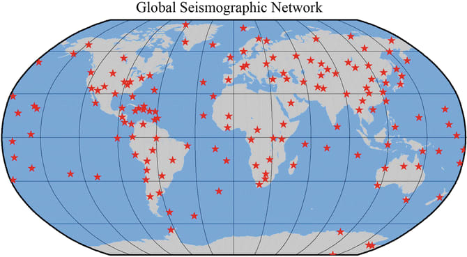
https://link.springer.com/rwe/10.1007/978-3-642-36197-5_193-1
02. GPS and Satellite Monitoring

https://www.studionetworksolutions.com/gps-in-cameras-and-video-production-workflows/
03. Artificial Intelligence and Big Data

04. Early-Warning Systems
05. Studying Animal Behavior